
Watch on weather: big chill
Some of us knew it was going to get seriously cold long before Jenny the Weather Lady or BOM (Bureau of Meteorology) gave us the details.

Higgins Storm Chasing's Facebook posts are best-known for their notifications of tropical cyclonic events in the summer, but in fact they monitor all kinds of weather phenomena. And the freeze eastern Australia is currently experiencing is certainly phenomenal.
On 6 July HSC posted these images. A big chill was spreading north from the cruel Southern Ocean and would reach Queensland the following week. Even tropical Queensland. It looked as if orange Bundy was the place to be. But subsequent days' isotherms revealed that I'd have to go to Weipa, right up in the Pointy Bit, to escape the blues.
The extreme blue straddles the state's southern border. As the weekend approached, chillier nights were heralded by biting southerly winds. 'Wind chill factor' became common parlance in weather forecasts. Clear night skies meant any warmth from sunny days was almost completely dissipated by sundown. I scanned the skies frequently for signs of the storm's approach.
Unsettled weather
Uniform mistiness
Early morning pink light

A second icy low was following the first. So, more than a week later, there's no let-up. BOM forecasts cold nights until at least this weekend.
It dropped to 6 degrees at 04:00 this morning where I live: BOM records 5 for Brisbane. It hasn't reached double figures yet and it's 08:15. The ABC is telling me (at 09:00) it's up to 11, which is only two degrees below average, they claim. Frost is being reported from various parts of Queensland: the Darling Downs had -3, and zero temps reached as far north as Hughenden, where we'll be in a month's time. There has been lots of snow in Australia's southern states, and some not that much further south of here. There were flurries in the Granite Belt, which is 1000 metres above sea level and experiences a different climate from the rest of South East Queensland; and blizzards in northern New South Wales just down the New England Highway from the Granites. There was even a report of a tornado at Burrumbuttock in New South Wales. I assure you I have not made up that name. I am pleased I don't live there.
Australians get very excited about snow, and think nothing of driving for hours to see it. There have been some beautiful frost and snow pictures posted, proper wintery scenes, from almost the length of eastern Australia. Just wish I could record a snow-in-Queensland shot myself.
These temps are not record-breaking. I have little recollection of this, even from 12 months ago, but my diary entry for 12 July 2014 records the same lowest temperature as today. It was reported as the coldest July morning in Brisbane for 103 years.
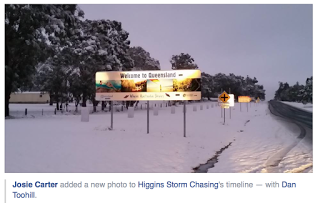
Post script 17 July 07:50: there have been the heaviest snow falls in the Granite Belt for 30 years – 8cm overnight – but most of it is expected to have gone by 10:00. The lowest temp in Brisbane was 6.8 at 06:30. This was posted to HSC's site, the best pic of the cold snap, taken near Stanthorpe.
PPS Midday 17 July: it was still snowing in Stanthorpe at 10:00. Later, ABC Radio's weatherman reported that Friday (17th) was the sixth consecutive day Brisbane temps failed to reach 20 degrees.
This post was last edited on 26 October 2016

