Wilderness 3
The next stage of exploration of Tasmania's remotest corner was riskier and heavily weather-dependent. The clear winner of the Best Day award was never part of the plan until a week before departure, when a chance conversation with a lady in the optician's gave me an idea that came to dramatic fruition. It meant stealing one of our days in Hobart but that was no great loss.
So, on 2nd January 2017, we drove to Cambridge Aerodrome, a few kilometres from Hobart International, and climbed into a single-engine, six-seater (at a push) Cessna that looked as if it was made of papier mâché and one puff of wind would blow it off the tarmac and away into Storm Bay.
It had been touch and go. I'd been studying the weather forecast for days, but it hadn't improved. We'd been told that, in Tasmania's southwest, there is some form of precipitation on 300 days out of 365; that pilots will not fly in strong wind or poor visibility; and that there is no point in flying if passengers can't see where they're going. At the end of the previous, increasingly rainy afternoon, my phone had rung. I feared the worst. Par Avion had talked to BOM (Bureau of Meteorology), however, and the weather front was going to clear away the following morning, so we would be good to go at lunch time, for half-a-day's trip rather than the full day we'd originally booked. I was just relieved that we could go rather than disappointed that the trip would be a few hours less.
Par Avion fly into Melaleuca every day that weather permits. They carry walkers to the start of the South Coast Track; birders tending a threatened species; and day-trippers in need of a remoteness fix. You can walk to Melaleuca along the Port Davey Track from the bottom of Lake Pedder, or you can fly in; but there are no roads.
We flew over Hobart, a city that I hadn't yet warmed to. Despite its watery outlook and mountain backdrop, I craved more World Heritage Wilderness. Perhaps we should have started our holiday in Hobart and then gone wild, but that would have meant coinciding with the Sydney to Hobart Yacht Race and its consequent overcrowding.
We headed down the Derwent estuary and then turned south.
North Bruny Island
Salmon holding pens at the mouth of the Huon River
The Neck, an isthmus connecting North and South Bruny islands
Settlements soon became smaller, fewer and further between. Southport (above) is at the end of the (main) road down Tasmania's southeast coast. Just to the south, Southport Lagoon (below) is the start of a coast that has largely been left to do its own thing. Further south still is the wonderfully named Recherche Bay, into which drains Cockle Creek at the eastern end of the South Coast Track. On average it takes eight or nine days to walk from Melaleuca, depending on weather conditions and how many pristine deserted beaches take your fancy. You need to be fit and a highly experienced bushwalker to even consider this trek.
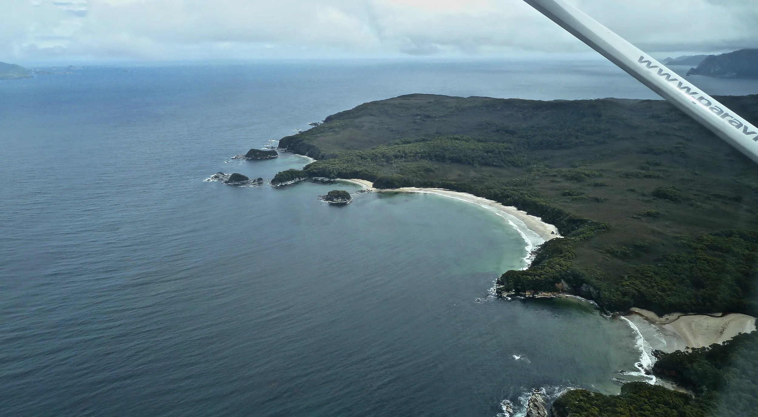
Once round South East Cape, Australia's most southerly point, the coast becomes remarkably desolate: the cliffs rugged and storm-weathered; the islands lonely; and the inlets intriguing.
Freney Lagoon, south of Melaleuca Lagoon
And then we were making our approach to Melaleuca, in an altogether different world. The landscape was unfamiliar and I'd have to say a bit strange: boggy buttongrass moorland, heath, and occasional clusters of gums. I'd expected primeval forest.
No shade nor shelter on the South Coast Track here
On older maps you might see the word 'mine' close to 'Melaleuca'. Given the mineral deposits up and down the west coast of Tasmania, it's no surprise that tin was once mined here, by Deny King, a respected bushman as well as hard-working miner. He extracted tin by hand from the 1930s until 1954 when he got himself a digger. He would lug the ore to his boat and ship it twice a year on a perilous journey to Hobart, returning with supplies. In 1957 he constructed a gravel airstrip to lessen his isolation, and huts for visitors once they began to turn up. King died in 1991 but his family still have a home on the creek. Mining scars are visible on the hillside before landing at Melaleuca.

We walked quickly from the airstrip to Melaleuca Creek and boarded a large, flat-bottomed tinny.

To avoid wash erosion, we had to travel slowly until we were in the open waters of Bathurst Harbour, which was massive. I had thought, especially in the largely grey weather we were experiencing by then, that the Harbour might be a tad dull, but its sheer size and remoteness and emptiness – we saw no wildlife – were impressive.
Thirty kilometres south of Lake Pedder as the crow flies, Bathurst Harbour is a shallow inlet – from 3 to 7 metres deep – formed by the partial inundation of a river valley and its alluvial plain. It is almost landlocked, being connected by the narrow, 12 kilometre long Bathurst Channel to Port Davey, a west coast inlet on the Southern Ocean. Bathurst's waters are dark brown, stained by tannin leached from buttongrass moorland and heathland. The Channel is at the lowest point in the distance in the picture below: we watched a sailing boat disappear. The combined volumes of Port Davey and Bathurst Harbour are more than three times that of Sydney Harbour. (If you are reading this as a potential visitor to Australia, you need to know that large amounts of water may be measured in Sydharbs. One Sydharb equals 500 gigalitres.)
We landed on the southern shore for lunch, although it was nearly 4 o'clock. Our pilot, who was also our skipper, thought we'd be more sheltered there than on the Celery Top Islands which, as you might expect, are covered with Celery Top Pines. There was wine and hot drinks, good salads and Tim Tams, but soon the cold cut through the small talk and we headed back. As we passed by one of the Celery Tops there was a solitary man on a beach. What a place to go into hiding, I thought.

Back at Melaleuca, we had about 15 minutes to investigate the bird hide. This is where volunteers were monitoring critically endangered Orange-bellied Parrots, which migrate from coastal areas of Victoria and South Australia to breed between October and March in this bottom corner of Tasmania. (Why?) It was bird tea time, and there were three OBPs on the supplementary feeding table. They were flitting between the table and the tree, where they were being harassed by Tree Martins. Artificial nest boxes supplement natural nests in tree hollows, and volunteers help to mitigate the threat of predators whenever possible. Juvenile OBPs are banded so their return, hopefully, the following year can be monitored. A few have been known to come back as many as nine times.
Roof of hide and Smithton Peppermint tree
The prognosis isn't good for the OBP, however. There's a captive breeding programme near Hobart with about 300 birds in it, but juveniles released into the wild tend not to do as well. Researchers are now looking at placing eggs in wild nests to see if that increases the survival rate. OBP numbers returning to breed at Melaleuca each year are dwindling: when we were there only 11 males and 3 females had come back so far. The reasons are many, but habitat degradation, the loss of genetic diversity, disease, climate change and predation are the most significant.
It was an enormous privilege to observe these beautiful little creatures, which are about the size of a budgerigar: joyful and sad at the same time.
It was time to head back. There was more good news. The weather was clear and calm enough for us to take the inland route back to Hobart, over the mountains. We took off around 6.
Our pilot took us first in a wide sweep over Port Davey so we could see the coast at the other end of Bathurst Channel. Our curtailed day hadn't allowed us time to do this on the boat. We turned inland for the Arthur Range.

Passing the Western Arthurs
The Portal (the dip to the right) between the Western and Eastern Arthurs
The merest glimpse of the southern end of Lake Pedder
Blot on the landscape: Ta Ann Tasmania's contentious hardwood veneer plant, plus Huon River
Huon Valley
We snuck over the back of Mount Wellington and Hobart's eastern suburbs, then popped over the Derwent to Cambridge. After profuse thanks to our pilot and guide, we were well on our way back into the city by 7:30. Fish n chips in the port were in order, and a few drinks to celebrate a cracker of a day.