The Catlins: into the New Zealand bush
We weren’t only leaving South Island’s second city behind, but the more popular tourist routes. My Kiwi advisor in Melbourne knew of our enthusiasm for the Australian bush, and suggested we explore The Catlins for comparison. The Catlins Coastal Rainforest Park nestles into South Island’s southeast corner: both forest and coast are well worth a look. Go for longer than we did!
Drive straight down State Highway 1 (SH1) from Dunedin as far as Balclutha – roughly halfway between Dunedin and Invercargill – and take the Owaka Highway. Then turn left at Otanomomo on to Kaka Point Road.
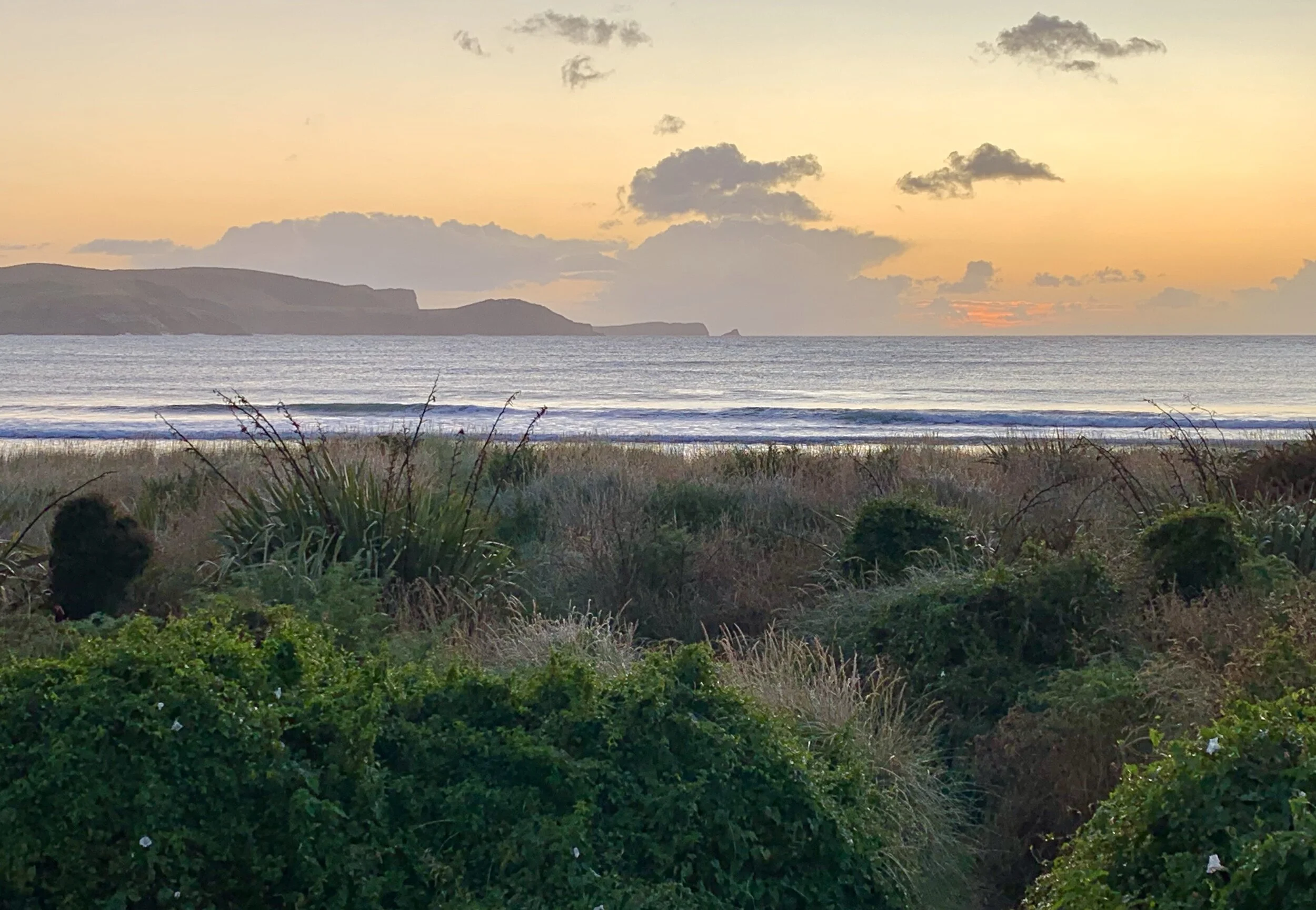
Just before Kaka Point, where we were staying, was Molyneux Bay. It was a grey day, and the seascape wasn’t pretty, but expansive and deserted of human activity, therefore appealing. Just out of sight around the curve of the Bay, South Island’s longest river (and the second longest in NZ), the Clutha, enters the Pacific. Its mouth used to be just in front of where this photo was taken.
Kaka Point & the Nuggets
It’s 10 km from the small settlement of Kaka Point to Nugget Point. A stone slab along the path to Nugget Point Lighthouse describes the Catlins coast in this way:
Deep, relentless forces buckle the layered land
Hiding bays and beaches between long, low folds of mountains
With rugged rocky headlands butting into the sea
Nugget Point Lighthouse
Kelp!
Yellow
Looking back towards Kaka Point
Where does the sky begin?
Gradually the sun came out. The sky was frantic with wheeling birds. At a safe distance from the path were some resident Royal Spoonbills, one on a nest. There were many basking and rock-climbing fur-seals – members of a large local breeding colony – and a nursery pool for youngsters.
Royal Spoonbill nesting
Seal pup nursery
The view of the Nuggets from the seaward side of the Lighthouse is stunning. The light was constructed in 1869 to protect small vessels trading along the coast to and from the Clutha River. The rocky remnants of the heavily eroded Catlins coast at this Point reminded early settlers of gold nuggets, dreams of which had enticed them to this part of the world.
From the Lighthouse
Why would a seal struggle to the top of a near-vertical stack?
A short walk back away from Nugget Point carpark is Roaring Bay. All was calm for our visit, but you can imagine how the name came about. There’s a newish bird hide from which to watch for endangered Yellow-eyed Penguins. The best chance is at dusk, but we looked and hoped anyway in the middle of the afternoon. A few people were inside the hide, but one numpty had to climb the rocks alongside. As we left, I first checked if he understood English and could therefore have read the signs, and then politely explained that, if a penguin was thinking of coming ashore but spotted movement, it would promptly turn back out to sea. Unbeknown to me, a ranger was coming down the path and heard me. He confirmed what I’d said to the numpty, then turned and asked me if I’d like a job! (Seriously, how good would that be?)
Roaring Bay
Back at Kaka Point, there were a couple of orcas, briefly, in the bay; and a good sunset developing. Nugget Point Lighthouse was reassuringly doing its job.
New Zealand Pigeon on the wire
Next morning, the beach looked serenely beautiful. (Apart from a giant’s severed claw.)
There was nowhere open for breakfast so we hit the road for Owaka, where our order took the best part of an hour to complete, and the neutron-dense muesli was served, unusually, by humourless people. We relaxed and studied the day’s route.
Corrugation
Purakaunui Falls
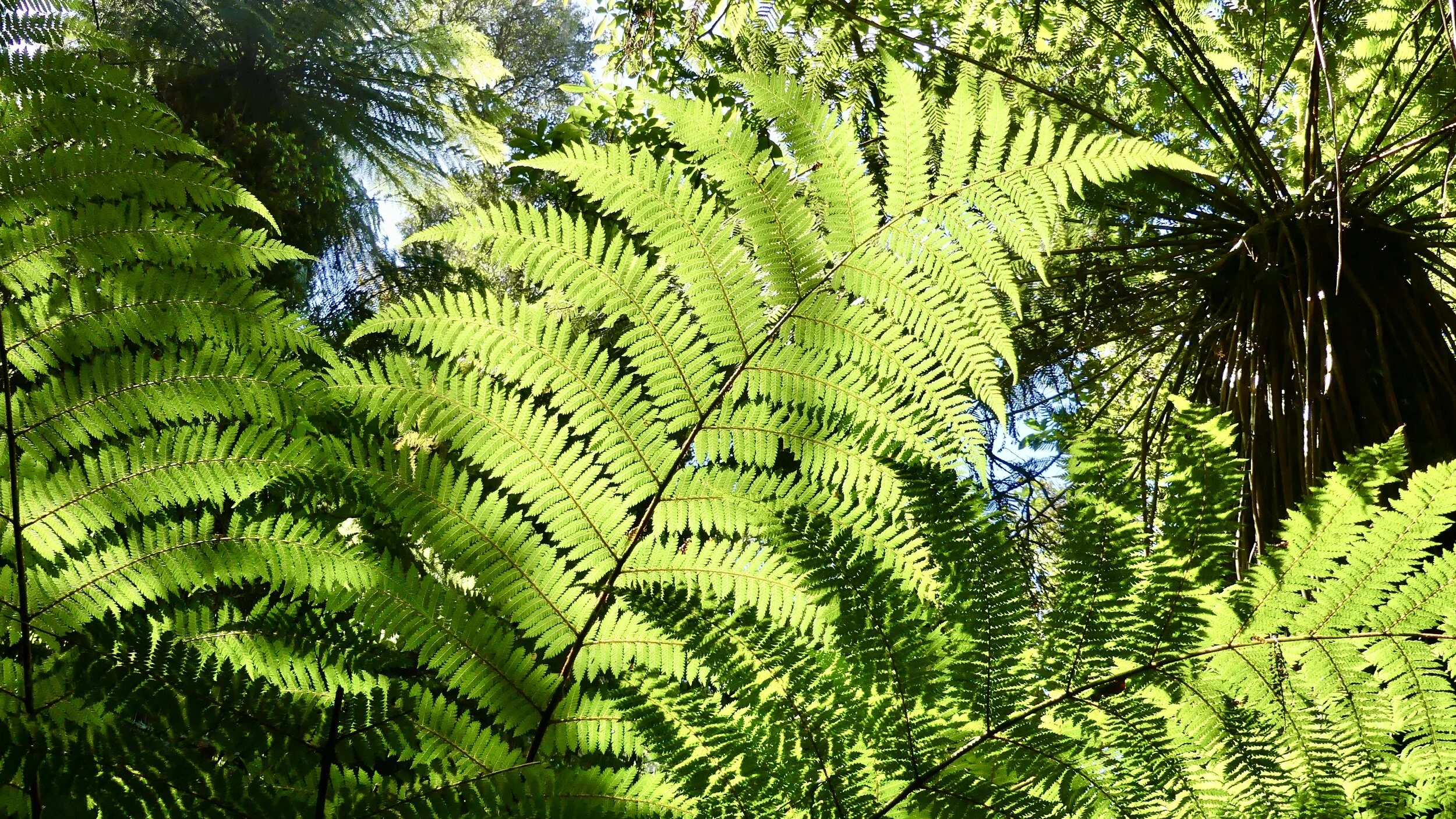
From Owaka, head southwest on the Southern Scenic Route. Turn left once you’ve crossed the Catlins River on to Purakaunui Falls Road, which becomes gravel but is well graded and easily, if slowly, driven in a 2WD. It’s only a 20-minute-or-so walk through mature beech and podocarp forest to the Falls and back. Podocarp forest is a mixture of tall and smaller conifers, shrubs, tree ferns and ferns. The waterfall would have benefitted from a heavy downpour a day or two prior to our visit, but the tōtara-and-fern forest was lush.
Silver Beech + tree fern
Not everything along the way was pretty.
The small yet fearless New Zealand Falcon
Tahakopa River
By now there was time pressure to get to Cathedral Caves while low tide allowed entry, but first we had to stop to admire Tautuku Bay from Florence Hill Lookout. The beach claims a perfect curve sculpted by Southern Ocean waves over 100,000 years; fine quartz sand eroded from ancient rocks; and milder temperatures than its latitude would suggest. There were even perfectly sized scudding clouds. This is the only place on the east coast of South Island to have continuous native forest from hilltop to beach; some of its trees are more than 1000 years old. The Southern Ocean extends for thousands of kilometres from here.
Native bush from hilltop to ocean
Cathedral Caves
The Caves are 10 km further on from Tautuku Bay and signposted off the Southern Scenic Route down a 2-km access road. There’s a small entrance charge (to help maintain the road); a 20-minute walk through podocarp forest; then a 10-15-minute walk along beautiful Waipati Beach. Entry is limited by season, tides and weather, so make sure you check tide timetables, available on the Caves website and in many tourist info places. There’s roughly a 1.5-2-hour window either side of low tide when you won’t get your feet wet. We had to walk briskly!
There are two cave entrances to what is one 200-metre-long system extending into the cliff – among the 30 longest sea caves in the world, according to Wikipedia. The ceiling is 30 metres high at one point. The rock is Jurassic sandstone: the Caves may have been formed tens to hundreds of thousands of years ago, which is a bit vague, but then the sandstone is about 160 million years old.
It goes without saying we would have loved to linger longer. To see more; explore in greater detail; or stand and stare – always a dilemma.
At the southern end of Waipati Beach is Chaslands Mistake promontory. Thomas Chaseland was an antipodean whaler who came upon a large herd of seals hereabouts, but delayed slaughtering them until next morning; by which time they had long gone on their way. Alternatively, it is thought he mistook the headland for Otago Heads. Hmmm.
As we emerged from the Caves the incoming tide was progressing.
McClean Falls
Not far further down the main road were McLean Falls on the Tautuku River; and a veritable fern fest. A waterfall not to be missed, they said; and they were not wrong.
The Falls drop 200 metres in upper and lower stages. The longest drop is 22 metres right at the top into a pool that must be lovely but we didn’t see: the lower half of the Falls cascades beautifully given enough water. The path to reach these water features climbs gently and easily for the most part. The agile and selfie-obsessed have been seen to clamber further up beyond the end of the path, using the Falls as a climbing frame, because they can. Then there’s a tendency for one’s carefully composed photographs of the upper level to include a head bobbing up that you didn’t even notice at the time you took the picture. Never take just the one image has long been my photo motto.
The ferns – including strange ferny appendages yet to be identified – were wonderful, varied and photogenic, as always. Can you ever have enough back-lit fern-frond photos. I doubt it.
And so we continued on to Curio Bay, our last stopover in The Catlins. As it turned out, there was a lot more still to do.