A bigger drought
As the rain sheets down in Brisbane this afternoon it's hard to imagine the large extent of drought-declared regions in Queensland. Most major towns in the Channel Country have received 0.0 mm of rainfall today: we're forecast to cop as much as 100 mm over the next 24 hours. Their need is far greater than ours.
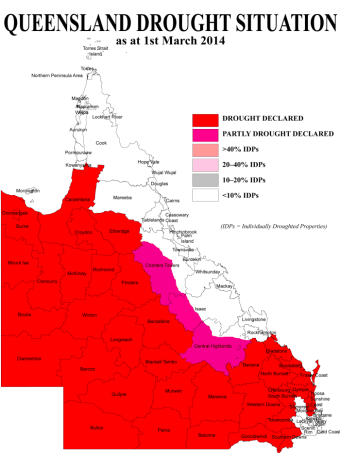
Do you remember the last map of drought-declared area of Queensland I posted back in January? (See More drought, January 2014; and also Drought, January 2014.) As of 1 March that map looked like this, courtesy of Queensland Department of Agriculture, Farming and Fisheries.

The drought is at the most widespread on record – 15 more shires were added – and it extends to parts of the coast for the first time. These include Noosa and the Fraser Coast. And in another extraordinary statistic, many of those shires are in the Wide Bay Burnett region, which was badly flooded only 14 months ago. Queensland's Agriculture Minister, John McVeigh, admitted that flood at one end of a 12-month drought assessment period and drought at the other has set a new precedent in drought evaluation. Which is probably not a claim to fame farmers in the region are relishing. One cane grower told the ABC that record-breaking drought following on so soon after flood was 'unchartered territory'.
Fairly predictably, the rest of the world seems to have cottoned on to the significance of record-breaking weather stats more quickly than either state or federal governments in Australia. UN climate chief Christiana Figueres said of freaky weather events:
If you take them individually you can say maybe it’s a fluke. The problem is it’s not a fluke and you can’t take them individually.What it’s doing is giving us a pattern of abnormality that’s becoming the norm. These very strange extreme weather events are going to continue in their frequency and their severity … It’s not that climate change is going to be here in the future, we are experiencing climate change.
California is also in the grip of a serious, record-breaking drought. The questions being asked and issues pondered are much the same as here is Australia. The West Coast's big dry is linked by some climatologists and scientists to the melting of Arctic sea ice. Warming at high latitudes has been greater than at mid latitudes – known as the Arctic Amplification – and this, it is suggested, has been responsible for a persistent ridge of high pressure over California, causing drier and hotter conditions than usual†.
Meanwhile, back on the other side of the Pacific, comes news this week that the development of an El Niño event is a distinct possibility during the southern hemisphere winter. The Bureau of Meteorology gives two-weekly updates on the Southern Oscillation, which you'll find explained via a link on the same page.
What El Niño tends to mean for eastern Australia is drier than normal conditions, which must be of great concern to Queensland farmers throughout the already drought-declared areas. What they need are prolonged periods of rain to replenish water supplies for the longer term. I'm happy to donate Brisbane's still-torrential downpour as well as bales of hay.
Here is a more wide-ranging context of a possible El Niño.
It's not just farmers who will suffer in this part of the world. A key driver of El Niño are extensive areas of warmer ocean temperatures in the Pacific. So it poses an extremely serious threat to the wellbeing of the Great Barrier Reef. The stress of higher ocean temperatures results in coral bleaching. And globally warming waters generally are too acidic for corals to survive. Another stress event may well be the final straw for the Reef.
The Guardian's 'obituary' this week may well be apposite – and it's certainly worth watching here.
This post was last edited on 29 March 2014


