
Australia's deep south
Here's a tip. If you're planning a trip to Tassie at the height of holiday season, make sure you get a hire car booked at the outset. As soon as you've fixed flights. And, if you change your plans, make sure to alter the hire car booking immediately, in case you forget later.
Our last trip had been booked early on in 2016, before we discovered we had more Christmas holidays than we thought. I changed the date of the return flights, at huge expense of course, but completely forgot to change the car dates. By the time I realised, there were no cars to be had on the island, we were told over and over, until 15 January, a week after our return home to Brisbane. While waiting for a takeaway coffee in Strahan, before driving out of range for days, I rang around Hobart car hire numbers and managed to find one; a much better car, in fact, than the silly small low-slung thing we'd driven for the first ten days. But it cost us dear.
So, on our 'free' day in Hobart – that is, no museums or scenic flights booked – we had to pick up a second car, then return the first to the airport. We were on the road by 11, but not back into the city. We had decided to go south, to find Huon pines and perhaps even the most southerly point of Tasmania. Skirting Mount Wellington – we didn't want to drive to the summit because we'd already flown over it and viewed the city and the Derwent from a great height – we headed for Huonville, about 35 minutes from the capital. Just outside town there's a useful tourist information office, and across the road, if they're in season, you can buy the best cherries you'll ever eat. Tasmania's more temperate climate, plus the fact that the island is fruit fly free so crop production requires fewer chemicals, ensures delicious fruit.
The Huon valley is a green and pleasant landscape, famous for its fruit production. Apples used to be king, but these days more exotic fruits are preferred.

Twenty minutes further down the Huon Highway (A60) is Geeveston. A thriving timber town until its pulp mill closed in 1982, Geeveston today is full of carved wooden figures that have become a tourist attraction. Representing local characters, the statues are short in stature, and I didn't find them the least bit appealing. Another lure for visitors is the Tahune 'Airwalk', 35 minutes west into deep forest. This is a Forestry Tasmania money spinner. We had been led to believe (by Huonville tourist info) that we'd be able to do the Huon pine walk without having to pay almost $60 (for two) to use treetop walkways, swinging bridges, hang gliding and the like. The only reason we drove down a narrow windy road for more than half an hour was to gaze up at some extraordinary tall trees – although we did spot a couple of squawking Yellow-tailed Black-cockatoos on the way. I complained that we'd been told we could do this and we'd driven all the way from Hobart… but they didn't care. We left without looking at anything.

Shy Yellow-tailed Black-Cockatoo

Then there was the matter of the 'Big Tree'. We had an oldish map of Tassie, a Hema map produced for RACQ in 2010; and on the C632 west of Geeveston is a red annotation, meaning 'Tourist point of interest'. No one seemed to know about this attraction, however. I asked in Huonville tourist office, but got blank looks. We looked for signs along the road; but there was nothing. As a result of the Tahune disappointment, we decided to try to find Big Tree. And when we get bees in our bonnets, we don't rest until the matter is resolved. It took a while but eventually we found it. What was once an attraction – a tall tree that I suspect had lost its top in a storm, but still boasts a mighty girth – has now been hidden away, with the help of 'fallen-log' obstacles and half-buried signs. Yet another example – and there are lots in Queensland – of routes being disappeared on behalf of influential interests, in this case Forestry Tasmania. Now they've got a money-making venture further on down the road, it's not in their interest for visitors to be distracted by a tall tree long before they get there.


The length to which they went to prevent us from reaching Big Tree
I suspect they've changed the name of the road to stop people locating the tree, so here are the co-ordinates if you want to find it: 43˚ 9' 7" S; 146˚ 47' 21" E.
Forestry Tasmania makes me cross. They try to convince the public they're something other than people who cut down trees. So there are signs by the roadside like these:


I was so angry about the disingenuity, the camera shook! This, in fact, is what Forestry Tasmania has been doing since 1850…


At least they don't pretend you're driving through original vegetation.
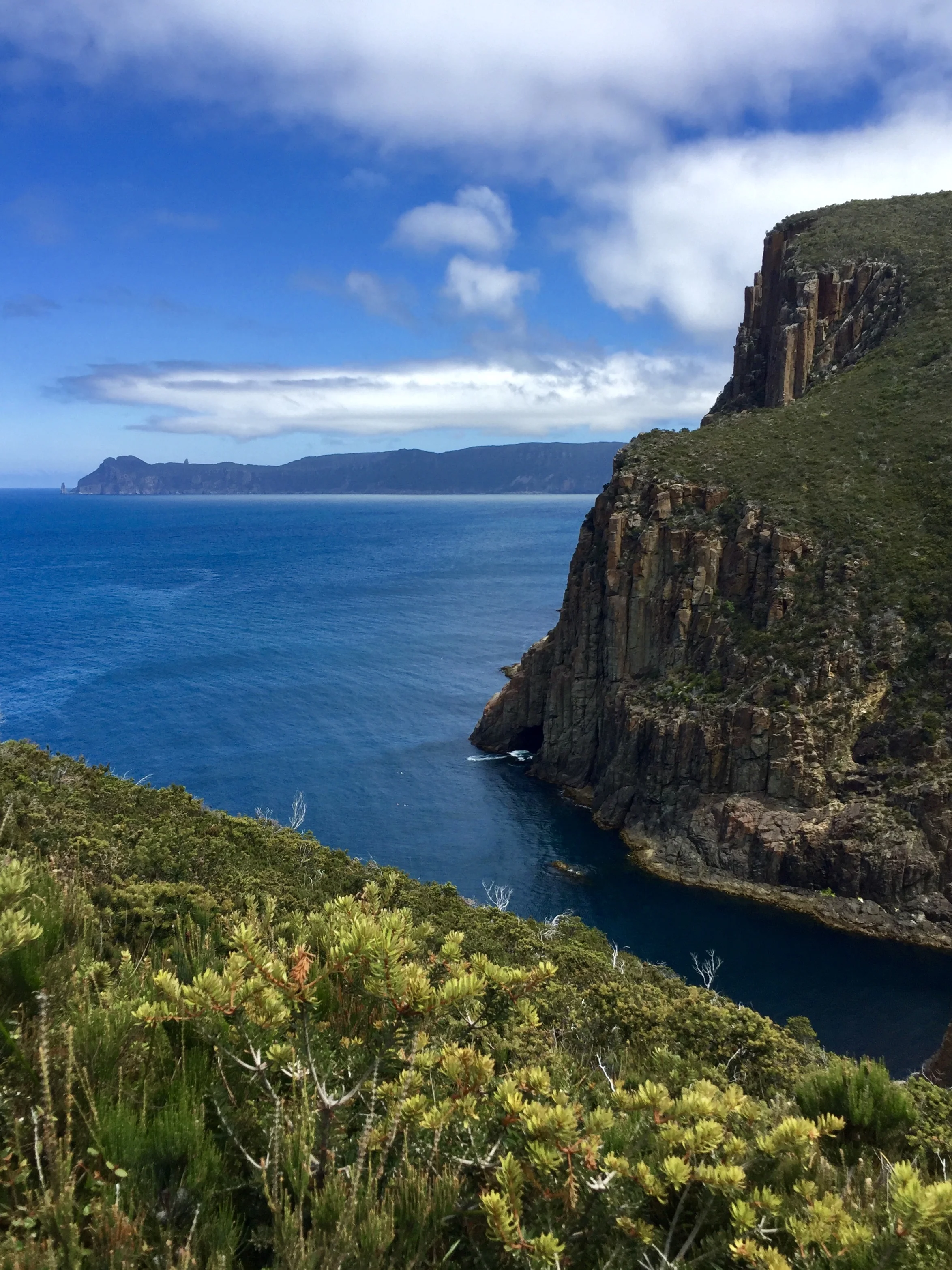
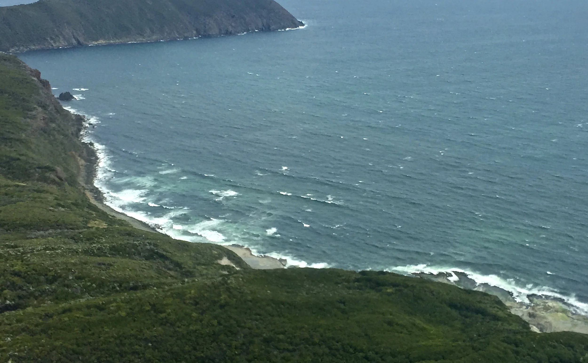
Back on Huon Highway, I had a fanciful notion we might reach Cockle Creek, which is as far south as you can drive in Australia and marks the start of the South Coast Track. South East Cape is the southernmost point of the main island of Tasmania (although there are islands further south that we'd seen from the air). I'm pretty sure the image below of Tassie's south coast, taken during our flight to Melaleuca, is looking towards the western shore of South East Cape. The next photo down shows Southport Lagoon Conservation Area, home to a large number of Tasmania's native plants and swirly sea greens that reminded me of Whitehaven Beach in the Whitsundays. Southport lies on the east coast south of Dover but north of Cockle Creek.

Time was not on our side, regrettably, and we only made it to Dover (top of page), 80 kilometres or so south of Hobart. We chose to have a walk about rather than hare further on down to Southport, only to have to turn around and come back. It was bleak grey and cold by this time, but the quiet little settlement of Dover appealed to me.
The area was first visited by Europeans – French explorer Bruni d'Entrecasteaux – in 1792. He named it Esperance after one of his ships. A settlement was established as a convict probation station in the 1840s, and by 1850 there were sawmills. Huon pine was shipped from the port to the other side of the world. The township of Dover was established in 1866. Today, fishing (salmon, crayfish and abalone) and apples are the mainstays. It is described as the last town of significance going south, and it's the last place you can fill up with petrol or buy supplies. The climate is described as consistently cool and cloudy all year round: it didn't make much effort for us.


Above and below: looking across Port Esperance towards South Bruny Island


Sooty Oystercatcher

Many Silver Gulls, one large Pacific Gull, and two Masked Lapwings

Tasmania's remote corners have an irresistible draw for me. They are untameable and undeveloped, often inclement, and populated by stranger than normal fauna and flora. They are places that absolve themselves of responsibility, seeming to say, 'Anything could happen here, should you venture forth.' D'Entrecasteaux also named Recherche Bay, into which Cockle Creek drains. In his native language, recherche means exotic, rare or obscure, and the French admiral ruminated upon arrival in January 1973:
It will be difficult to describe my feelings at the sight of this solitary harbour, situated at the extremities of the globe, so perfectly enclosed that one feels separated from the rest of the universe. Everything is influenced by the wilderness of the rugged landscape. With each step, one encounters the beauties of unspoilt nature, with signs of decrepitude; trees reaching a very great height, and of corresponding diameter, are devoid of branches along the trunk, but crowned with an everlasting green foliage. Some of these trees seem as ancient as the world, and are so tightly interlaced that they are impenetrable.
I could have said the same about Bathurst Harbour, the Edge of the World or, further afield, The Remote and Beautiful Diamantina. The impact of such landscapes is profound. They make you feel isolated, yet within, as an integral bit part. Their impression is all the greater for dark brooding skies, biting wind or relentless heat. They inspire long after you have left them behind; you reminisce longingly; or urgently recommend. Except for a special few that shall never be mentioned, lest they be spoiled.
This was going to be our last tour of Tasmania. But that may not be possible.
It was a relief to get back in the car in Dover, and hard to believe it was the middle of summer. We drove straight back to Hobart. Later, we only had to walk a couple of blocks to Franklin for dinner – this place alone is reason to visit the state capital – and by then it was boots and gloves weather.